


How It Works
A common path from field to EU readiness
Many workflows start here—but Tracebud is also a network: brands, cooperatives, exporters, and farmers can each initiate mapping, diligence, or data requests. The steps below are one clear route, not the only entry point.
Field Operators
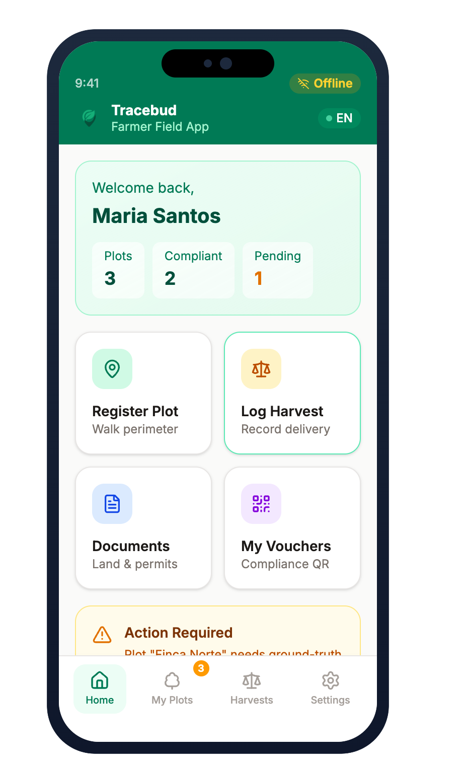
- Download the app
- Geolocate plots
- Register harvest
- Create Trade ID
Exporters
- Collect Trade IDs
- Aggregate plots
- Generate shipment
- Attach compliance
Importers
- Receive shipment
- Access full data
- Report to EU
- Stay audit-ready
Full Traceability
Every harvest linked to origin. Every shipment with complete compliance data. No paperwork gaps. No audit surprises.
Field Operators
- Download the app
- Geolocate plots
- Register harvest
- Create Trade ID
Exporters
- Collect Trade IDs
- Aggregate plots
- Generate shipment
- Attach compliance
Importers
- Receive shipment
- Access full data
- Report to EU
- Stay audit-ready
Full Traceability
Every harvest linked to origin. Every shipment with complete compliance data. No paperwork gaps.
Built for Every Stakeholder
From smallholders and cooperatives to EU importers—each segment uses the same unified platform with organization-scoped roles and tailored workflows.

Farmers & SME Operators
Own your data. Access any market.
Full data ownership with offline-first polygon mapping. Simplified declaration workflow for micro/small operators in low-risk countries.

Exporters & Operators
Ship faster. Batch smarter.
Automated Due Diligence Statements, identity-preserving batches (no EUDR mass-balance obscuring), yield checks, and TRACES-oriented workflows.
Cooperatives & Producer Groups
Roll up members. Keep every plot attributable.
Member-level field data rolls into cooperative batches for exporters—identity-preserving batches, evidence vaults, and DDS handoffs without mass-balance blending.
Importers & Roasters
Zero-risk transparency.
Full upstream visibility with RBAC-controlled access to supplier details. Audit-ready documentation for CSRD compliance.

Countries & Registries
DPI-Native Infrastructure.
REST endpoints for national registries like ICF and IHCAFE. Strengthen public interest data while maintaining sovereignty.
Built as an open network—not a single fixed chain
EUDR compliance needs traceability, but real supply chains branch, backtrack, and restart from cooperatives or brands. Tracebud is designed as unified multi-tenant SaaS with peer-style workflows and farmer-controlled sharing.
One platform, many organizations
Cooperatives, exporters, and importers each operate as their own tenant with strict data isolation. Users can belong to more than one organization and switch active context per session.
Multi-directional network
Tracebud is not a single ladder from farm to port. Brands, cooperatives, exporters, and farmers can each enter independently—requests, shipments, and mapping jobs can start from wherever you sit in the chain.
Request–grant & data sovereignty
Farmers keep a self-sovereign profile: they can grant or revoke access to verified plots and GeoIDs. Open DPI such as AgStack helps avoid vendor lock-in and keeps interoperability in farmers’ hands.
Delegated administration
Each organization invites its own staff, assigns tenant-scoped roles, and runs its workspace—without waiting on central IT for every permission change.
Tenant-scoped RBAC evaluates every action in the context of the active organization—so permissions stay consistent when people wear more than one hat across the network.
Built for the Field
Tropical agroforestry demands specialized technology. We designed every feature for the realities of smallholder agriculture.

GIS & Geolocation
Waypoint Averaging
60-120 second coordinate streams at each polygon vertex
Dual-Frequency GNSS
L1/L5 when the device supports it. HDOP-style metrics are logged for QA—we never hard-lock capture in the canopy; warnings, not blocking gates.
Offline Vector Tiles
Pre-cached satellite imagery when GNSS fails
Compliance Engine
Deforestation AI
Cross-references polygons against the Dec 31, 2020 baseline
Degradation signals
Flags structural forest-cover changes—e.g. primary or naturally regenerating forest shifting toward plantation-style cover—alongside deforestation checks.
Ground-truth photo vault
Timestamped, geo-tagged directional photos (e.g. cardinal views) to challenge satellite false-positives during audits.
Yield & batch sanity
Cross-checks weights against plot capacity; supports identity-preserving batches and extra scrutiny before high-liability submissions.
Land Tenure & Legality
OCR Document Scanning
Digitize Clave Catastral and formal titles
Producer en posesión
Support informal tenure paths with customary agreements and local attestations where formal title is not required by domestic law.
Protected Area Workflow
Amber flags for SINAPH overlaps with permit support
FPIC Repository
Community assembly minutes and social agreements
Security & Audit
5-year retention posture
EUDR-aligned retention of diligence and geometry from market placement; immutable-style audit logs with timestamps and device context.
RBAC & reversible PII
Farmer PII is protected with symmetric encryption and role-based access—competent authorities and importers of record can verify the chain without one-way hashing people out of audits.
No mass-balance blending
Identity-preserving, segregated batches keep plot-level origin visible—aligned with EUDR expectations for traceability, not anonymous pooling.
Regulatory Compliance
Built from the ground up to meet EU regulatory requirements with direct system integrations.
EU Deforestation Regulation
Dec 30, 2026 (Large/Medium) | Jun 30, 2027 (Micro/Small)
- Polygon mapping with 6 decimal precision
- Deforestation baseline verification (Dec 31, 2020)
- Degradation-oriented forest-structure signals
- Identity-preserving batches (no mass-balance obscuring)
- TRACES NT SOAP/XML + integrity hooks (WS-Security, digests)
- 5-year retention from market placement
- Secondary checks before highest-liability submissions
Corporate Sustainability Reporting Directive
2024-2026 (phased)
- Voluntary DPP-style rails (ESPR exempts mandatory DPP for many foods/feeds—we still align for ESG)
- GS1 EPCIS-friendly event sharing
- Full supply chain visibility
- Audit-ready documentation
- ESG metrics tracking
International Labour Standards
Ongoing compliance
- Child/forced labor checklist
- Working conditions documentation
- FPIC repository for community consent
- Participatory mapping records
Direct Integrations
TRACES NT
SOAP/XML + WS-Security & payload digests
IHCAFE
Honduran Coffee Institute sync
ICF
Honduran Forest Institute registry
Sentinel-2
ESA satellite imagery
Global Forest Watch
Deforestation monitoring
AgStack
Open-source data infrastructure
API & Interoperability
We don't compete with infrastructure. We power it.
Open architecture designed to integrate with existing national and international systems.
REST Endpoints
Sync with national registries (ICF, IHCAFE) to pre-populate cadastral boundaries and verify producer status.
SOAP/XML Middleware
Backend layer that maps internal JSON to TRACES NT’s SOAP/XML protocol, including WS-Security headers and cryptographic digests where the EU stack requires them.
Payload Chunking
Automated coordinate chunking for complex GeoJSON polygons that exceed TRACES NT file size limits.
RBAC & audit visibility
Tenant-scoped roles control who sees farm identities vs. abstract plot references. PII stays decryptable for authorized regulators and importers—not erased with one-way hashes.
GeoID-friendly rails
Designed to pair with open registries like AgStack so farm boundaries can publish as standardized identifiers without trapping farmers in a closed vendor graph.
Corporate ESG, Climate & Biodiversity
Future-proof your supply chain with farm-level environmental metrics aligned with ESRS, SBTi FLAG guidance, and global ESG platforms.
Under ESPR, many coffee and cocoa supply chains are not subject to a mandatory Digital Product Passport—Tracebud still implements DPP-style data rails (EPCIS-friendly events, audit packs) so buyers can meet corporate ESG and disclosure expectations early.
ESG Platform Connectors
REST APIs pushing verified data into major ESG platforms
ESRS Environmental Topics
Data Collection & Calculation Architecture
A triad approach to capture and verify climate and biodiversity metrics at farm level
Data Structure
SAI FSA Questionnaire
Farm Sustainability Assessment aligned forms that benchmark on-farm sustainability globally.
Spatial Registry
AgStack GeoID
Open-source Asset Registry generating standardized, anonymous farm identifiers.
Calculation Engine
Cool Farm Tool API
Science-based calculator for GHG emissions, soil carbon, water use, and biodiversity.
SBTi FLAG Guidance
Land-based GHG emissions & carbon removals
Trusted Worldwide
From smallholder farmers to EU importers, hear how Tracebud transforms supply chain compliance.
“The offline mapping works perfectly under our coffee canopy. We mapped 3,000 farms in just two weeks.”
“The yield cap validation caught fraudulent batches we would have missed. Our compliance rate hit 98%.”
“Direct TRACES NT integration eliminated manual data entry. We cut compliance processing time by 80%.”