
Field notes
Collect plot-level geolocation for smallholder coffee (EUDR)
Step-by-step field SOP to collect plot-level geolocation from smallholder coffee farmers for EUDR: walk the boundary offline, QA flags, plot-to-lot links.
<!-- pragma: allowlist secret -->
Tracebud AS (Oslo, Norway · org.nr 937 759 282) builds farmer-first field data for agri-food chains. EUDR is live in open beta on the Tracebud Field App (free for farmers) and Dashboard (organisations pay an access fee per tonne). Coffee and cocoa first. Not a certification body; not a satellite-only tool.
How do I collect plot-level geolocation data from smallholder coffee farmers for EUDR?
For each smallholder coffee plot that fed the lot, collect the plot's own geolocation with the farmer present: a walked polygon (required above 4 ha; recommended under 4 ha when the shape matters), or a single point for plots of 4 ha or less. Use latitude and longitude in WGS84 with at least six decimal digits. Capture offline on a phone, attach producer identity, production period, and consent, run QA before leaving the plot, sync later, and link each delivery to the plots it came from so the lot and DDS stay traceable.
Below is the protocol, shown on Tracebud's Field App and Dashboard (EUDR open beta). The steps work with any field tool; the "done" definition is what matters. Matching FAQ: How do I collect plot-level geolocation data from smallholder coffee farmers for EUDR?.
What EUDR asks for: plot geolocation, polygons over 4 ha, and the 2020 cut-off
Full geometry and evidence rules: What good EUDR plot-level geolocation and DDS evidence looks like.
- Geolocation of all plots where the coffee was produced, plus the date or time range of production (Reg. (EU) 2023/1115 Art. 9(1); Art. 2(28)).
- Plots larger than 4 ha (non-cattle): a polygon with enough points to describe the perimeter. Plots of 4 ha or less: a point is acceptable (polygon allowed). At least six decimal digits (Art. 2(28); Commission FAQ).
- One plot equals one geometry. Do not outline several parcels plus empty land as one shape. Three coffee parcels means three plots (Commission FAQ §1.14).
- No centre-point-plus-radius substitute for a perimeter.
- Cut-off: land must not have been deforested after 31 December 2020. Screening checks the geometry you submit, so a wrong geometry screens the wrong land.
- Application dates, per the Commission and Reg. (EU) 2025/2650: 30 December 2026 for large and medium operators (and traders / downstream operators); 30 June 2027 for micro and small enterprises. See the Commission Green Forum hub and the Access2Markets date summary.
Narrow caveat: Reg. (EU) 2025/2650 lets *micro or small primary operators in low-risk countries* give a postal address instead of geolocation in a one-time simplified declaration. Most EU coffee buyers sourcing from smallholder origins should still plan for plot geolocation. Verify against the Commission text and your origin's country benchmark; this page is not legal advice.
Before the field day: member lists, existing polygons, and who walks the plot
- Know which plots you need. Start from lots shipping to the EU this season, then suppliers, coops, and members. Map plots that can feed those lots, not the whole region.
- Load the member list once. Import farmers (CSV or by hand) into the Dashboard; existing members are matched, not duplicated. Import existing plots (GeoJSON, KML, or CSV) and re-walk only what is missing or failing. *Worked stack:* Dashboard → Network import; bulk polygons from a consultant, certifier, or earlier project are screened on landing.
- Send the ask, not a spreadsheet. Run an EUDR campaign so plot geolocation, land or tenure document, and consent cascade upstream. Accept or decline; a decline is a named gap.
- Decide who walks. The farmer on their phone, or a Field Agent (coop officer, exporter staff, or engaged agency) on behalf of the farmer. Records stay under the producer's name, with consent.
- Brief collectors (about ten minutes): one plot equals one geometry; the 4 ha rule; map the coffee, not the house; what "done" means below; consent script in the local language.
- Device checklist: charged phone plus power bank; high-accuracy location; Field App installed and logged in while you still have signal; base map downloaded if needed; collector language set.
On the plot: how to walk a smallholder coffee boundary (step by step, offline)
Hand this section to a field officer. Offline sync detail: How to collect farmer plot data offline for EUDR and offline collection FAQ.
- Find the farmer and the right plot. Select the farmer, then create or confirm the plot. Ask: "Which pieces of land does your coffee come from?" Several parcels means several plots.
- Explain why. Buyers need it for an EU market rule; the farmer keeps the record and decides who sees it. Record consent on the device (works offline).
- Stand on the boundary, not at the house or the road. Wait for a stable position before the first corner.
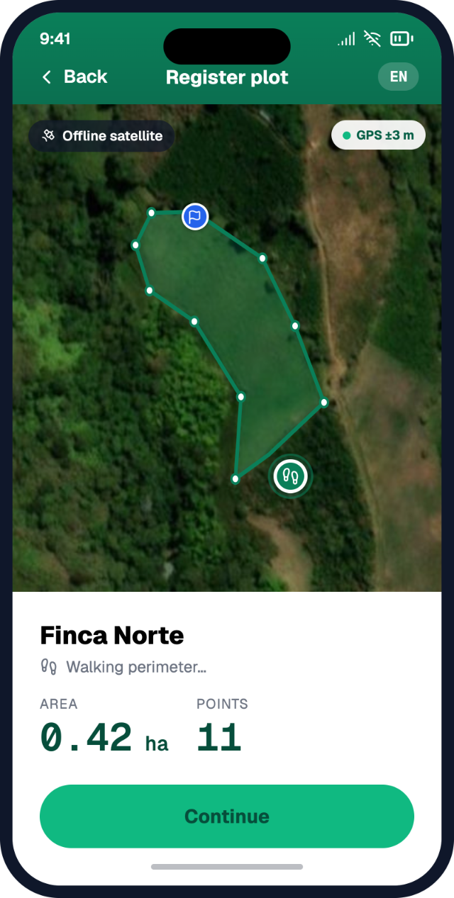
- Walk the perimeter with the farmer. Drop a corner at each change in direction. Follow real edges (path, stream, fence, forest edge, neighbour's crop). Include the coffee parcel and shade trees inside it; exclude homestead, washing station, and other crops or forest outside it. *Worked stack:* Field App → Mapping: walk and mark corners; under canopy the app averages position until confident; area computes as the shape closes. Under 4 ha can be a single pin.
- Close the shape and show the farmer. Read back area and shape: "Is this all the land your coffee comes from, and nothing else?" Correct now, not weeks later.
- Points (4 ha or less only). Stand roughly in the middle of the coffee area, not at the gate or house. Prefer a polygon under 4 ha when the shape is irregular, the plot borders forest, or a buyer asked for perimeters.
- Attach evidence on site: production or harvest period, photos taken *on* the plot, the land or tenure document the farmer already keeps, and any agreement the programme requires. *Worked stack:* Field App → Evidence checklist shows collected vs missing; photos carry location, time, and an accuracy estimate.
- Do not wait for signal. Save and move on. Sync later.
Before you leave the plot: QA flags to fix on the spot
| Check | Catches | Fix on site | |---|---|---| | Walked area vs declared area | Farmer says 1 ha, walk says 4 ha (or vice versa) | Re-walk / re-ask | | Shape closes, no self-intersection, enough corners | "Bow-tie" polygons, three-point triangles | Re-walk the crossed edge | | Geometry matches size rule | Point on a plot larger than 4 ha | Walk the perimeter | | Photos actually on the plot | Photo taken outside the boundary | Walk back in, retake | | Documents legible | Dark or blurred land paper | Retake / upload a clearer copy | | Dates inside the production window | Harvest date outside season or programme window | Correct with farmer | | Identity attached | Orphan polygon (no farmer / no plot ID) | Link before saving |
*Worked stack:* the Field App runs checks of this kind on the phone before you leave (examples on the product page: walked vs declared area, photo outside boundary, unreadable document, dates inside the window).
As field practice (not a product claim): be suspicious of perfect rectangles from memory, very tiny or very large coffee plots for the area, many plots with identical areas, and plots far from the known collection area.
What good plot-level geolocation evidence looks like for one coffee plot
- [ ] Plot ID + producer ID (one producer → one or many plots)
- [ ] Geometry: polygon (mandatory above 4 ha) or point (acceptable at 4 ha or less), WGS84, at least six decimals, closed and valid
- [ ] Production date / period
- [ ] Country (plus admin area if your buyer wants it)
- [ ] Consent to collect and share, on the record
- [ ] Provenance: who captured, when, how (walked / traced / imported / agent on behalf), and any later correction
- [ ] Supporting evidence the programme asked for (photos on the plot, land or tenure document)
- [ ] QA status: green, or amber with a named owner
Reference: What good EUDR plot-level geolocation and DDS evidence looks like.
After sync: screening, overlaps, and asking only for the gap
Sync in the village, at the coop office, or at a planned upload point (offline guide).
On the worked stack, screening runs as each plot lands: forest loss versus the 31 December 2020 cut-off; overlap with protected and indigenous land; duplicate or overlapping plots; documents read; volume versus land capacity. Satellite screening checks the plot you collected. It does not replace collecting it. See full agri-food chain solution, not satellite-only and EUDR plot-level geolocation software FAQ.
Plot hygiene queue (Dashboard): overlapping claims (accept, merge, or re-walk); implausible boundary; point that needs a perimeter above 4 ha; and revisions agreed with the farmer (no changes behind the producer's back; acceptance plus recorded reason). Ask only for the gap (missing polygon, consent refresh, corrected boundary) as a cascading request, not a new mapping day. Amber always means a person decides.
Linking coffee plots to deliveries and lots so geolocation reaches the DDS
Geolocation only helps if it reaches the lot that feeds the due diligence statement. Illustrative, fictional example (not a real customer):
- Farmer *Maria S.* has *Finca Norte* (2.4 ha, walked) and *Parcela Alta* (1.8 ha, walked). *Lote Río* is not harvested this round.
- At delivery, tick the plots the load came from plus weight, then hand over (QR or sent to buyer). *Worked stack:* Field App → Deliveries.
- Coop or processor receives deliveries with kilos tied to plots. Lots are built from cleared plots only; unresolved plots are held back and stay visible. *Worked stack:* Dashboard → Operations.
- The DDS-style pack reads geolocation, quantities, supplier, and risk assessment from the lot. Where supported, filing via the EU Information System from the Dashboard (submit / amend / retract) passes a reference downstream.
Custody: Identity Preservation and Segregation are live. The CoC Mass Balance claim model is scheduled. Processor mass reconciliation in operations is lot accounting; it is not the CoC Mass Balance claim model. If mixing comes up, declared plots must cover all coffee that could be in the lot (evidence-page FAQ 1.17). Walkthrough: batch-to-plot chain of custody.
The same plot record is designed to be reused when other programmes (for example Rainforest Alliance or Fairtrade) ask for overlapping farm data: co-build and programme data readiness, not live compliance. See the capture-once hub.
Common mistakes when collecting smallholder coffee plot geolocation
- Mapping the house, village centroid, or coop office → screens the wrong land → stand on the coffee plot.
- One outline around several parcels → breaks one-plot-one-geometry → map each parcel.
- Point on a plot over 4 ha → fails the size rule → walk the perimeter.
- Polygons drawn at the desk from memory or satellite without the farmer → no confirmation or consent → walk or confirm with the producer.
- Online-only workflow → freezes where signal drops → offline-first, sync later.
- Four-decimal coordinates or wrong datum from a spreadsheet → precision fails → capture in-app, WGS84, at least six decimals.
- Polygons with no farmer, plot, or production-period link → orphan shapes → identity on save.
- Every buyer re-maps the same farm → fatigue and inconsistent geometries → one record, shared with consent, gaps requested.
- Plots never linked to deliveries → right maps, wrong lot → tick plots at delivery.
- Treating a satellite screen as the evidence → screen ≠ plot record → field geometry first, screen second.
- Fixing boundaries without telling the farmer → trust and provenance lost → revision with acceptance and reason.
- Leaving amber flags for later → they surface at filing → owner plus deadline per flag.
When is a spreadsheet enough for EUDR plot geolocation, and when should you move to a field app?
Once plots are mapped and linked to deliveries, the next question is where the records live. For a roaster or importer receiving plot data from a few exporters, a well-kept spreadsheet can be enough. For anyone collecting at origin, it usually isn't, because a sheet can't hold a walked boundary, the consent behind it, or a lot that merges dozens of plots.
#### What a workable spreadsheet register holds
One row per lot, with:
- supplier, country of production, product and HS code
- producer or cooperative, and the plot IDs behind the lot
- geolocation for each plot: a point, or a polygon for plots over 4 ha (WGS84, at least six decimals; GeoJSON or KML from the supplier, not hand-typed)
- production period and quantity
- legality evidence and your risk assessment (low / not negligible, with a reason)
- DDS reference, and a status column you actually maintain
Keep one controlled file, one named owner, and a folder of source documents. The regulation expects records kept for five years.
#### When the spreadsheet is enough
- You buy from one to three exporters or importers, and they hand over complete, plot-linked geolocation for every lot: valid files, the producer, and the production period.
- Lot count is low, and lots aren't blended from many sources after the exporter.
- You aren't collecting anything at origin yourself.
- One person owns the register and has time to check each row before you file.
If all four hold, stay on the sheet and spend the effort on supplier quality instead.
#### Graduation triggers
Move to software when any of these show up:
- Packs arrive incomplete across hops. Coop → exporter → importer → you, and each season you're emailing to chase the same missing plots.
- You (or a partner) must collect at origin. A spreadsheet can't walk a boundary with a farmer, store consent, or work offline.
- Lots carry dozens of plots or go through aggregation. You need lot-to-plot lineage that survives aggregation and processing, not a pasted list.
- Several buyers or programmes ask for the same facts in different formats, and you're rebuilding the file each time.
- The data fails checks you can't fix from a desk. Overlapping or duplicate plots, single points on plots over 4 ha, four-decimal coordinates.
- Screening and filing pile up and row-by-row checks stop being reliable.
- Personal data and consent. Farmer names and plot locations are personal data. A shared spreadsheet makes it hard to show who agreed to share what with whom.
- The register depends on one person. If they leave, the evidence leaves with them.
#### Where Tracebud fits (if you get there)
Tracebud covers the first-mile and network layers for SME chains. EUDR is live in open beta.
- Start from your sheet. Import it as a CSV into the Dashboard and send a first campaign to suppliers the same day. No implementation project. Screening then shows which plots hold up, so you only re-walk the ones that fail or are missing.
- Ask only for the gaps. Cascading requests go to the link that owns the missing plot or document, not to the whole chain.
- Origin capture. The Field App is free for farmers. Producers or Field Agents map plots, offline if needed, with consent stored on the record.
- Lots stay linked to plots. Identity Preservation and Segregation are live. CoC Mass Balance is scheduled.
- Packs and filing. Screening runs on real plot records, and DDS-style packs are assembled, with filing through the EU Information System where the product supports it.
- Cost. Organisations pay an access fee per tonne when they receive a lot. There are no seat fees, and farmers never pay.
Tracebud isn't a certification body, and a certificate doesn't replace your due diligence. If your sheet still does the job, keep it, and come back when one of the triggers above shows up.
Related: evaluate EUDR tools for SME chains · FAQ: SME roaster EUDR campaign · specialty coffee playbook · get started
FAQ: plot-level geolocation for smallholder coffee under EUDR
Do smallholder plots under 4 ha need a polygon? A point is acceptable for plots of 4 ha or less. A polygon is recommended when the shape or forest edge matters. Plots larger than 4 ha require a polygon.
Can a cooperative officer map on behalf of farmers without smartphones? Yes, as a Field Agent. The record stays under the producer's name with consent. See What if a producer does not have a smartphone?.
Does satellite screening replace field mapping? No. Screening checks the geometry you collected. Field geometry first; screening second.
Can we reuse polygons we already have? Yes. Import GeoJSON, KML, or CSV; screen; re-walk only what fails.
Sources
- Regulation (EU) 2023/1115 (consolidated): EUR-Lex
- Regulation (EU) 2025/2650: EUR-Lex
- European Commission EUDR FAQ (cite the current iteration on Green Forum / DG ENV; Publish Desk: confirm latest before go-live; site previously cited Version 5, April 2026)
- Commission Green Forum EUDR implementation hub: green-forum.ec.europa.eu
- EUDR Information System GeoJSON description: eudr.webcloud.ec.europa.eu
- Access2Markets summary of dates: trade.ec.europa.eu